Saturday, July 13, 2013

Training Hike #6: North Kaibab Trail

Location: North Rim of the Grand Canyon
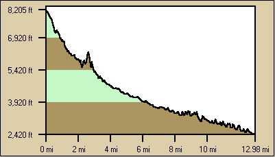
Elevation: 8241 ft
Elevation gain/loss: 2800 ft
Distance: 6 miles
Difficulty: Strenuous/Difficult
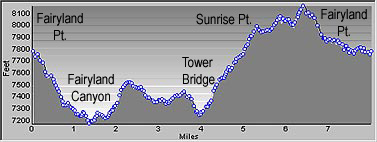
Description: super steep, heat creeps in 1/2 mile down, next time start at 5 am, no later than 6 am, water at Supai tunnel w/ restrooms, bring a hat! Plan on 1 ltr water per hour, twice as long to hike back up, multiple , log/stone steps, sandy at the beginning


Thursday, July 11, 2013

Training Hike #5: Fairland Loop

Location: Bryce Canyon
Rating: strenuous
Distance: 8 miles
Time: 3 hr. 45 minutes with dinner break and stops for blisters
Elevation: 7700 ft
Elevation Change +/-: 2309 ft
Description: mostly exposed, steep sections, tower bridge at half way point, a little slick/ rocky from less use. went counterclockwise this time
Elevation Profile of Fairyland Loop Trail


Training Hike #4: Parley's Summit

Location: East of SLC, exit 140 off of I-80, after Lamb's Canyon at Summit Peak Park
Rating: Moderate/ difficult
Elevation: 8300 ft.
Elevation Gain: 967 ft.
Distance: 5 miles aprox
Time: 1 hr. 45 minutes
Description: mostly shaded, grease mark trail begins down the road marked by a white tipped post, options to take short stack around, watch for bikers, lots of flowers, too narrow for poles
Trail Head


View from Summit


Training Hike #3: Yellow Fork


Location: Herriman, Utah near Rose Canyon
Trail Rating: Intermediate
Distance: 6 miles
Elevation: 5000 ft
Elevation Changes: 700 ft increase, 
Time: 2 1/2 miles with stops
Description: some steep sections, exposed hot sections, beware of horse manure/flies along horse route. Out and back trail. Need to cross creek at 1 mile mark, not clearly indicated, next to a group of picnic tables

 Paige resting at the top- what a determined hiker!

 Dust storm!
Trailhead

Training Hikes this far...

I started out with hikes around Oquirrh Lake with my pack... nothing too exciting or noteworthy.